
About Ubrique
Ubrique is a Spanish village located in the south of Andalusia in the Sierra de Cádiz. According to the INE, in 2016 it had a population of 17,766. Its surface area is 71 km² and has a density of 244.75 population / km². Its geographical coordinates are 36º 40 ‘N, 5º 26’ O. It is located at an altitude of 337 meters and 118 kilometers from the provincial capital, Cádiz.

Geography
Ubrique is a town that is part of the Route of the white villages, being at the entrance of the Natural Park of Grazalema and Los Alcornocales Natural Park.
Thanks to its location, it is surrounded by a rocky landscape characteristic of mountain ranges where a great diversity of flora abounds (olive trees, fir trees, cork oaks, oaks, etc.) and abundant fauna (griffon vultures, Egyptian vultures, etc.), existing mainly on the highest mountainous areas located in the Aljibe Valley. The Ubrique river divides it in half, although it also has other rivers such as the Tavizna.
History
In its vicinity, the remains of the Roman city called Ocuri have been located. Not far away, a fortress called Cardela was built in Muslim times, which today is called Castillo de Fátima. It was conquered in 1485 by Rodrigo Ponce de León, Duke of Arcos, passing in 1490 to belong to the house of Arcos. In 1501 the repopulation began and the nucleus of the one that would grow Ubrique1 began to be consolidated.
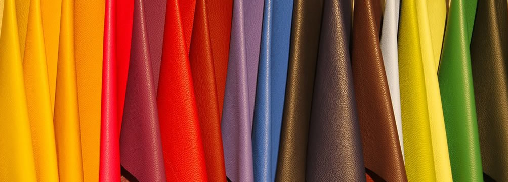
Already in the 18th century, multiple skin factories following the Muslim tradition of leather goods were installed. During the first republic he lived through a turbulent period, having two local governments, in a municipal area where the possessions of the Duke of Osuna were predominant.
Today it is one of the main centers of leather work in Europe.
Economy
Ubrique lives from his skin industry. Ubrique’s skin is internationally recognized in the leather goods industry.3
Currently the skin industry in Ubrique is so developed that it manufactures for the most important brands in the world, for example Loewe, as a result, a high percentage of its production is exported. This supply of the manufacture of leather goods to the most important brands in the world becomes in this sense in the town of the mountainous region of Cádiz more updated in international fashion. At the end of the manufacture of their leather goods on the most fashionable fashion catwalks in the world.
Demography
In the sixties, Ubrique began a path of higher industrial development, on a larger scale in the production of leather goods. Later in the seventies this development is greater despite the economic crisis that suffered this decade, which could not with this boom that pushed Ubrique. Although it was affected by the crisis, partially and not totally. Some factories were affected slightly and in others however the shaking was stronger. But as it was so strong the large production of leather goods that already existed in this town could not defeat this industry in the leather sector. For this reason, the population increase in Ubrique is seen in the sixties and seventies.
This being the case, not only more children were born in Ubrique, but also the families of the surrounding villages who were migrating to Ubrique in search of work and well-being for their families, as a result of all of this from the Skin Industry. of Ubrique. Therefore, in this town there are many families whose predecessors do not belong to Ubrique.
Already in the eighties and nineties is reflected the settlement of this population with a demographic increase, as a result of the development of the Undine industry, from the nineties and up to the present date there is a balance in the number of inhabitants, being among the 17,000 and 18,000 inhabitants.
Currently the industrial sector of leather goods employs 58% of the active population.
Monuments
Castle of Fatima
Ocuri, Roman ruins of the s. II
Castle of Fatima, ss. XII-XIII: It is located on the southern flank of the Sierra de la Silla. It was configured as a strong defensive bastion that exercised control in the western passage to the valley of the Ubrique River. It was a strategic position whose possession was opposed by Muslims and Christians, passing from one to the other successively, until at the end of the 15th century it became the property of the Dukes of Arcos. What remains of this monument shows with completeness that we are facing a fortress from the time of Arab domination, which is why we could date it around the 12th and 13th centuries. It presents a manifest deterioration and in its constructive techniques we visualize a certain diversity as manifested by the remains of its defensive towers and its cisterns.
Caserío of the high zone, ss. XVII-XIX.
Fuente de los nueve caños, of Roman origin.
Town hall. The town hall is a good example of the neoclassical civil architecture of the first half of the 19th century. Its façade is integrated into the superposition of two pure geometric figures: a square crowned by a triangle, and the architectural elements that articulate it are pilasters, entablatures, half-point spans, which are essential to the classicism that reigns in this nineteenth-century style.
House Dintel. The origin of Casa Dintel dates back to the 16th century. It was acquired by a confectioner of Italian origin, who made the lintel a small masterpiece. It is composed of small tiles that form a mosaic, representing a small scene of the Italian opera “Dulce Amore”.
Manor House. The construction dates back to 1925. It is located in the framework of the houses that frame the old town, specifically in the Plaza del Ayuntamiento. The peculiarity of this building is found in its façade, in which the murals with representations of Roman mythology and floral motifs stand out.
Edificio ABC (Santa María) The building is popularly known as Santamaría in honor of an enterprising manchego who arrived in Ubrique in 1916 and created in 1931 in this building one of the most important leather factories. Santamaría is considered the pioneer of Moroccan marketing in Ubrique. The factory occupied at that time the central façade, which is also flanked by two unique houses. Of these, the murals of the patrons of Ubrique stand out, on the right San Sebastián and on the left the Virgen de los Remedios. The main attraction of this stately building is that it is richly decorated with ceramic tiles, with floral and geometric representations. In sight are its gardens, where a central fountain stands out and benches whose tiles are adorned with flowers, shields, animals, Don Quixote sequences and Goya paintings.
The Fountain of the Plaza. It is a monument that frames four water jets. It is conformed by a base flanked by Tuscan pilasters, body covered between overlapping pilasters between which the following inscription appears: “TO SPHINES OF THIS VILLA, THIS WORK WAS DONE, BEING CORRECTIVE MR. D. FERNANDO MÁRQUEZ BARREÑO. YEAR 1727. ” It has a broken triangular pediment with cross and spherical pinnacles.
The Rodezno
The Roman Track
Tres Cruces From the entrance of the village, you can see a peculiar cross located in the cut of the mountain, which together with two others, Viñuela and Benalfí, form the symbols of an old popular legend.
Casco Histórico The historic center of Ubrique is located in the upper area between the 16th and 18th centuries, beginning an expansion towards the low areas in the 19th century that will give rise to the modern Ubrique. The original houses participate in typical mountain typology, with masonry walls, gable roof, with rectangular and recessed doors and windows, and balconies or small windows in the upper bodies. As it happens in other serranas localities, some of them are located on the own limestone rock that surrounds them.
Peñón de la Becerra Located in the old town. It teaches the way in which the ancestors of the locals adapted the paved terrain to the construction of the primitive dwellings in which they lived.
Nature
Los Alcornocales Natural Park
Soil, humidity and traditional use have been the determining factors to maintain the largest and most productive and productive cork oak mass on the Iberian Peninsula, Los Alcornocales Natural Park.
Located in the province of Cádiz and part of Málaga, it extends from the mountains to the young Natural Park of the Strait, presenting a great diversity of reliefs and landscapes. This richness is reflected in all areas: flora, fauna, climatology, history and folklore, constituting an ideal place to visit and enjoy activities as diverse as mushroom picking and the practice of sports in nature.
The main responsible for this wealth is water, which is present in numerous rivers, streams and reservoirs that, in addition to supplying the province, are suitable for fishing and recreational activities. But above all, it highlights the humidity coming from the coast, which accumulates forming cloud forests in narrow and deep valleys called canutos. Under these conditions a very unique flora is preserved, belonging to the Tertiary Era, the Laurisilva. It is characterized by smooth and bright leaves, which take advantage of the humidity and scarce light that the alders that border the canutos pass through. Thus, between the aroma of the laurel, the beauty of the ojaranzo in flower, elegant durillos and holly trees, you will walk through this species of jungle, in the company of the sounds of the aquatic blackbird, the skillful kingfisher and the warblers or finches, that hide between the ferns.
The sandstone soils, which have favored the dense cork oak, also harbor gall oaks and Andalusian oak in the most humid areas. In these woods they hunt the eagles, short-toed, and rat-tailed eagles, as well as hawks, hawks, and owls. In the heights, the rocks appear and on the poor soil appears the herriza, dense scrubby scrub of different species adapted to soils rich in metals such as aluminum, among which abound, for example, aromatic. In this space the mountain goat and numerous raptors live, highlighting the griffon vulture, Egyptian vulture, Bonelli’s eagle, eagle owl and peregrine falcon.
In the low and argillaceous zones the acebuchal appears clarified from immemorial times to give way to the pasture that will feed the typical cattle of the zone, the retinta cow. On the slopes, the Mediterranean scrub appears, with cistus, heather, gorse, torviscos and hawthorns. For them runs the Moorish deer, autochthonous and emblem of big game, as well as fallow deer, deer and carnivores such as genets, badgers and especially mongoose, with the largest population of the peninsula.
In a Park so complete and diverse, fit other activities, ranging from mountaineering at the peak of Aljibe or Picacho; the speleology in the Ramblazo-Motillas enclave, or the descent of canyons in La Garganta de Buitreras, one of the few areas prepared for this risky practice and which, due to its uniqueness, has been declared a Natural Monument.
For the most traditional routes are recommended on horseback, such as those established in La Almoraima.
Sierra de Grazalema Natural Park
On horseback between Cádiz and Málaga, these mountain ranges appear abrupt and contrasted because of their turbulent geological history. The erosion produced by the water has created canyons of great beauty, such as the Green Throat which, with 400 meters depth, guarantees a magnificent descent. Likewise, it has created an underground labyrinth of chasms and caves, among which the Hundidero-Gato complex stands out. It is the longest cave in Andalusia, notable for hibernating about 100,000 bats, the largest population in Spain.
logo_pn_sierra_grazalema In this space, with the highest peaks of the province of Cádiz, ascents to summits such as El Torreón or El Reloj are classic among mountaineers. To climb there are rocks and walls in Peñón Grande, Aguja de las Palomas and Peñaloja, in Grazalema, Cortados de Montejaque and Beaoján and La Veredilla, La Diaclasa and Cintillo, in Benaocaz.
The most emblematic element of the Park, apart from the dense Mediterranean forest of oaks, cork oaks and gall oaks, is the pinsapo, mainly concentrated in the Sierra del Pinar, as it is the rainiest place on the Peninsula. This species is descended from the Central European firs that formed here great forests in the glacial epochs. Today these pinsapos inhabit only in this space, in the Natural Park Sierra de las Nieves and Sierra Bermeja (both in the province of Malaga). The visit to Pinsapar, as well as to other enclaves of the Reserve Zone, can be done only at certain times of the year and with limited visitors, so it is recommended to request prior information.
Another point of interest is the upper course of the Majaceite River, where you can see the otter, and where its elms, willows and poplars form a characteristic gallery forest. These and other species, up to 300, can be seen in the nearby El Castillejo botanical garden, next to the El Bosque visitor center.
The conserved vegetation also gives rise to a rich fauna, maintaining with seeds, autumn fruits and pastures the deer, roe deer, rabbit, partridge and the mountain goat. The numerous birds stand out, with 136 different species, such as the Bonelli’s eagle and the Griffon vulture, the latter having the largest colonies in Europe. The ecosystem is completed by other emblematic carnivores such as the genet and weasel, peregrine falcon, booted and short-toed eagles and eagle owl.
The visitor will be able to know the richness of the Park on foot through numerous marked itineraries or on horseback; from the air, in the hang glider and the paraglider in Cerro Albarracín (El Bosque); and, from the water, practicing canoeing in the Zahara-Gastor reservoir. One of the most important routes, the old Roman road, connects Benaocaz with Ubrique, a municipality famous for its traditional leather goods and leather garments. La Cueva de la Pileta in Benaoján, internationally known for its prehistoric remains, represents a true natural museum whose visit is highly recommended. For lovers of cultural tourism the route of the white villages represents a great opportunity to know part of the Arab legacy in Andalusia.
To highlight the large number and variety of hiking trails, many of which run through landscapes of great beauty.
Rafael Alberti Park
Route of the Viewpoints
The Route of the Viewpoints is easy to access and of low difficulty that runs through the Casco Antiguo and, for the more daring, surrounds Ubrique by its four cardinal points. Although at first they seem to be strong rises, taking breath and slowly, they are the daily step of all the locals.
Mountain bike routes
The Cycling Association of Ubrique offers bike lovers the 2014-2015 mountain bike route calendar as well as the 2015 cycle touristic calendar.
This calendar is made up of 23 routes by mountain bike and 22 by road bike, running all stages through the Natural Parks of Sierra de Grazalema, Los Alcornocales, Sierra de las Nieves and Sierra Nevada, so you can enjoy this form of splendid landscapes and a wide variety of natural spaces.
For more information you can access the official blog of the Ubrique Cycling Association.
Trails on horseback
In the southernmost part of the Sierra de Cádiz, on the Ruta de los Pueblos Blancos, the municipality of Ubrique is located in the northwest of the province, forming the border of two of the most important Natural Parks of Andalusia. On your right, the Sierra de Grazalema Natural Park, with an extensive forest of fir trees, a relic of the Tertiary Era and, to the left, the largest cork oak forest in the Iberian Peninsula and one of the largest in the world, the Los Alcornocales Natural Park .
The trails on horseback from Puerto Calvito and the Mojón de la Víbora are located between these beautiful places, whose limestone nature leads it to become a morphologically unique area within the Betic Cordilleras, designated as Special Protection Areas for Birds, and included in the proposal of the Autonomous Community of Andalusia as Places of Community Importance.
Besides being able to be traveled on horseback, these trails offer the possibility of walking on foot.
Walking trails
Ubrique, due to its privileged geographical location between the Sierra de Grazalema and Los Alcornocales Natural Parks, is an unbeatable place for hiking and direct contact with nature.
Through the following pages taken from the publication “300 Trails of the Province of Cádiz” published by the Environment Service of the Provincial Council of Cádiz you will be able to know different interesting information about the nine trails located in Ubrique and its surroundings, being These are the following: Ocuri, Castillo de Fátima, Callejón de las Mocitas, Cerro de los Batanes, Climb to the Cruz del Tajo, Millán Gorge, Mojón de la Víbora, Birth of Garciago and Garganta de Barrida.